Category:Maps of the Sykes-Picot Agreement
Jump to navigation
Jump to search
Media in category "Maps of the Sykes-Picot Agreement"
The following 29 files are in this category, out of 29 total.
-
 Approximate Sykes-Picot overlay on current borders.jpg 747 × 580; 38 KB
-
_on_8_May_1916_(cropped).jpg/120px-François_Georges-Picot_signature_from_the_Sykes_Picot_Agreement_Map_(signed)_on_8_May_1916_(cropped).jpg)
-
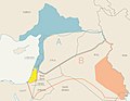
 Israel's northern border by the Sykes-Picot Agreement.svg 1,115 × 920; 121 KB
-
_on_8_May_1916_-_(cropped).jpg/120px-Mark_Sykes_signature_from_the_bottom_of_the_Sykes_Picot_Agreement_Map_(signed)_on_8_May_1916_-_(cropped).jpg)
-
 MPK1-426 Sykes Picot Agreement Map signed 8 May 1916.jpg 3,322 × 3,225; 5.7 MB
-

-

-

-
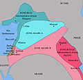
 Peace-conference-memoranda-respecting-syria-arabia-palestine5.jpg 2,000 × 1,334; 653 KB
-

-
 Sykes Picot Agreement Map signed 8 May 1916.jpg 1,024 × 633; 373 KB
-
 Sykes picot ar.jpg 452 × 433; 27 KB
-
 Sykes picot-he.jpg 452 × 433; 45 KB
-
 Sykes picot.jpg 452 × 433; 51 KB
-
 Sykes-Picot Agreement He.svg 625 × 858; 160 KB
-
 Sykes-Picot ko.svg 800 × 900; 106 KB
-
.gif/92px-Sykes-Picot-1916_(cropped).gif) Sykes-Picot-1916 (cropped).gif 661 × 861; 32 KB
Sykes-Picot-1916 (cropped).gif 661 × 861; 32 KB
-
 Sykes-Picot-1916 cropped.gif 459 × 442; 12 KB
-
 Sykes-Picot-1916 german.gif 677 × 876; 33 KB
-
 Sykes-Picot-1916-ar.png 677 × 876; 120 KB
-
 Sykes-Picot-1916.gif 677 × 876; 35 KB
-
 Sykes-Picot-ar.svg 800 × 900; 104 KB
-
 Sykes-Picot-es.svg 800 × 900; 383 KB
-
 Sykes-Picot-hu.svg 800 × 900; 107 KB
-
 Sykes-Picot-ptbr.png 802 × 901; 142 KB
-
 Sykes-Picot-sr.svg 800 × 900; 111 KB
-
 Sykes-picot.png 704 × 585; 597 KB
-
 Sykes-Picot.svg 800 × 900; 106 KB
-
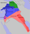
 تقسيم الشام والعراق - سايكس بيكو.jpg 2,279 × 2,020; 1 MB


_on_8_May_1916_-_(cropped).jpg)


.gif)


_on_8_May_1916_(cropped).jpg)
Categories:
- Sykes-Picot Agreement
- Maps of the Ottoman Empire in World War I
- Maps of the history of Iraq
- Maps of the history of Israel
- Maps of the history of Jordan
- Maps of the history of Lebanon
- 20th-century maps of Palestine
- Maps of the history of Syria
- Maps of the history of the Middle East
- Maps of the Turkish War of Independence
- Maps of 20th-century Arabia