
Both Atlas Obscura and CityLab look at efforts by the Humanitarian OpenStreetMap Team to update and improve the quality of maps in Puerto Rico in the wake of Hurricane Maria.
Previously: Volunteers Mapping Post-Hurricane Puerto Rico.
Both Atlas Obscura and CityLab look at efforts by the Humanitarian OpenStreetMap Team to update and improve the quality of maps in Puerto Rico in the wake of Hurricane Maria.
Previously: Volunteers Mapping Post-Hurricane Puerto Rico.
A rare Braille globe held by the Queensland State Library is being digitized so as to create a 3D-printed replica. The globe, invented by Richard Frank Tunley in the 1950s, is one of the last copies still in existence and is in poor physical shape—problematic for something designed to be touched. That’s where the replica comes in. It’s funded by the library foundation’s crowdfunding initiative, which will also help fund the original globe’s restoration. ABC News, Sydney Morning Herald. Media release. [ANZMapS]
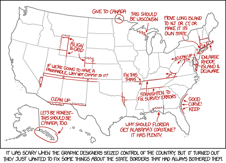
Today’s xkcd. Apparently, the graphic-designer dictatorship will, in their zeal to fix the state borders, overlook Point Roberts.

At 82° north latitude, Quttinirpaaq National Park is on the northernmost tip of Canada’s northernmost island, Ellesmere Island. It takes days to fly there and requires you to hire a charter plane. Fewer than 50 people visit every year. And along with the remote northern communities of Grise Fiord and Resolute Bay, it’s just been added to Google Street View: Parks Canada staff backpacked across the park with the iconic Street View camera. More from CBC News and Google.

The Conversation has a piece on how indigenous peoples in the Amazon are using “counter-mapping” to reclaim not only their ancestral lands, but as a way to counter the colonial process of mapmaking itself.
Maps have always been part of the imposition of power over colonised peoples. While map-making might be thought of as “objective”, it is fundamentally political, a necessary part of controlling a territory. Maps inscribe borders, which are then used to include some and exclude others.
During a late 19th-century rubber boom, Amazonia became increasingly well mapped out as the young nations of Peru, Bolivia, Brazil and Colombia vied for territorial control. The rights and interests of Amazonian peoples were never included in this process and they would be continually denied rights, recognition and citizenship from these nations until the 1980s and 1990s. Even following legal recognition, their territorial rights—critical for their continued existence—are still often ignored in practice.
These marginalised people are now working together to reclaim the process of mapping itself. In the central Brazilian Amazon there has been a recent flurry of “counter-mapping”, used by forest peoples to contest the very state maps that initially failed to recognise their ancestral territorial rights.
[via]

I love track network maps. I’ve told you about Franklin Jarrier’s rail maps, Transport for London’s track network map, and Andrew Lynch’s network map of the New York subway. Now for something grander: the SNCF’s map of the entire French rail network (28 MB PDF). It shows TGV lines, freight-only lines, number of tracks, and electrification. It even numbers the lines. In print, it measures 121 × 101 cm—I’d totally put this on my wall. Que c’est magnifique! [Transit Maps]
 Last year I told you about The Un-Discovered Islands, a book by Malachy Tallack that told the stories of some two dozen islands that were once thought real but are now no longer on the map. It existed only as a British edition, though a U.S. edition was said to be forthcoming. That U.S. edition is coming next month from Picador, so readers in North America will be able to lay hands on a copy more easily, should they wish. [Amazon]
Meanwhile, Tor.com has published an excerpt online.
Previously: Mapping Scottish and/or Nonexistent Islands; The Un-Discovered Islands Reviewed.
Will Geary’s TransitFlow project is an experimental set of tools to build animated transit flow visualizations, built from Transitland’s open-source transit schedule data. More than a dozen visualizations are available in video form here; each shows the flow of trains, buses and other forms of transport over the course of a day. Very high visual appeal. More at the Guardian. [Metrocosm]
Having ruffled fannish feathers with a post critiquing Middle-earth’s mountains and another admitting that they don’t like fantasy maps, Alex Acks returns with a Tor.com post about the problems with Middle-earth’s river systems. Specifically, the Anduin, which breaks all kinds of hydrological rules: it cuts across mountain ranges (and parallels the Misty Mountains), it lacks tributaries along one side and it doesn’t seem to have much of a drainage basin. “Even if you grant the mountains as things created by the Valar doing their Valar-thing—which means my mental excuse for the Anduin cutting through mountain ranges is void—it still looks weird from a geological perspective.”
Another point Acks makes, about Tolkien’s influence on fantasy maps in general, that I should file for later:
Just as Tolkien’s novels have had a massive influence on epic fantasy as a genre, his map is the bad fantasy map that launched a thousand bad fantasy maps—many of which lack even his mythological fig leaf to explain the really eyebrow-raising geography. The things that make me cringe about the geography of Middle-earth are still echoing in the ways we imagine and construct fantasy worlds today.
Previously: ‘The Messed Up Mountains of Middle-earth’; Two Views on Fantasy Maps; The Territory Is Not the Map.
James Cheshire reports that the Ph.D. thesis of the “father of GIS,” Roger Tomlinson, has been digitized. Tomlinson completed his thesis, “Geographical Information Systems, Spatial Data Analysis and Decision Making in Government,” at the University College London’s Department of Geography in 1974. It can be downloaded as a PDF at this link.

We’ve seen a lot of maps correlating election results with other demographic or geographic data, but SurveyMonkey’s exit polling on the correlation between politics and gun ownership seems particularly stark, particularly in the context of recent events. In the 2016 U.S. presidential election, nothing predicted who you’d vote for more than whether you had a gun in the house. If only gun-owners voted, Trump would have swept 49 states; if only non-gun-owners voted, Clinton would have won at least 48.
“Over all, gun-owning households (roughly a third in America) backed Mr. Trump by 63 percent to 31 percent, while households without guns backed Mrs. Clinton, 65 percent to 30 percent, according to SurveyMonkey data,” the New York Times reported. “No other demographic characteristic created such a consistent geographic split.”
Writing for the Washington Post, Jenny Rough looks at how people get themselves lost hiking, despite having a cellphone or a GPS for directions, and how to get reoriented when lost in the wilderness: by remaining calm, by getting yourself situated, and yes, by learning how to use a map. [Geo Lounge]
Bellerby & Co., makers of expensive bespoke handmade globes, continues to get all kinds of good press: earlier this week they were featured on CBS Sunday Morning.
 The odd thing about A History of Canada in Ten Maps, the new book by Adam Shoalts out today from Allen Lane, is that it’s almost entirely uncontaminated by maps. It’s not just because the electronic review copy I received (via Netgalley) contained no images of the maps being referred to in the text: I expect that will be rectified in the published version; if nothing else I was able to find an online version of each map (a gallery follows below). It’s that in the text itself the maps are quite literally an afterthought.
It turns out that A History of Canada in Ten Maps isn’t really a book about maps, or mapmaking, but exploration. For Shoalts, the maps are the evidentiary traces of the stories he really wants to tell. In nine of the ten cases, those are stories of Canada’s exploration; in the tenth, a key battle of the War of 1812. Combined, those stories form a mosaic tale of nation-building, one that supports the kind of national mythmaking that the previous government in Canada was particularly fond of.


Today marks the U.K. publication of two atlases in the Times atlas range: the eighth edition of the Times Reference Atlas of the World and the seventh edition of the Times Mini Atlas of the World.
The Reference is right in the middle of the Times atlas range: it’s inexpensive (£30 list, compared to £150 for the Comprehensive, £90 for the Concise and £50 for the Universal) and presumably a bit less unwieldy. The Mini, on the other hand, is positively dainty: at 15.1 × 10.6 cm, it’s smaller than a mass-market paperback! (Obviously the covers above are not to scale; see the somewhat-out-of-date comparison chart for the various atlas sizes.)
According to Amazon, both are available in Canada next month, and in the U.S. in April 2018. (If for some reason you cannot wait, here are direct links to the U.K. store: Reference, Mini.)