Skip to content

The Map Room

  • About
    • Contact
    • FAQ
    • Privacy Policy
    • Reviewing Guidelines
    • Submit a Link
  • Archives
  • Books
    • Map Books of 2024
    • Book Reviews (2011-present)
    • Older Book Reviews (2006-2011)
    • Reviewing Guidelines
  • Extras
    • Blogroll
    • Fantasy Maps
      • Recent Posts
      • Bibliography
    • Fiction About Maps
    • Publications
  • Subscribe & Follow
    • Email Digest
    • Bluesky
    • Facebook Page
    • Mastodon
    • RSS Feed
  • Patreon

Robert Lazzaretti, Fantasy Mapmaker

Published on 6 July 201518 November 2017 by Jonathan Crowe

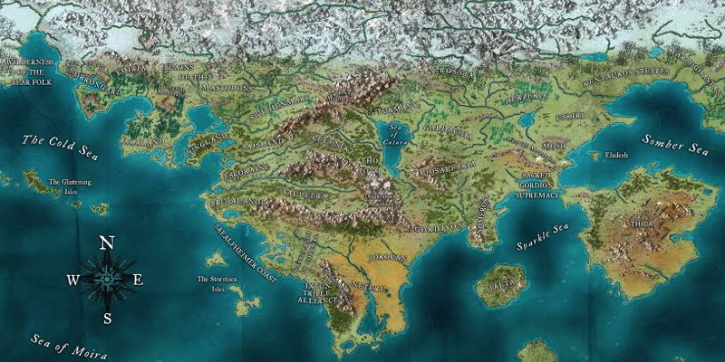
Lou Anders interviews fantasy mapmaker Robert Lazzaretti, who drew the maps for Anders’s Thrones and Bones series (Frostborn, Nightborn). I can never get enough information about the process of making fantasy maps.

Previously: Mapping An Ember in the Ashes; How to Make a Fantasy Map.

Related Posts

Link•Categories Maps and Literature•Tags fantasy map design, fantasy maps

Post navigation

Previous RIP Yahoo Maps
Next The Best Map of Pluto Ever (Until Some Time Later This Month)

About The Map Room

The Map Room is a blog about maps by Jonathan Crowe. Since 2003 he has covered everything from antique map collecting to the latest in geospatial technology. More about The Map Room.

Subscribe and Follow

  • Email Digest
  • Bluesky
  • Facebook
  • Mastodon
  • RSS Feed

Support The Map Room

Support The Map Room on Patreon, help the website go ad-free and allow me to spend more time writing and sharing information about maps.

Affiliate Disclosure

The Map Room participates in the Amazon, Bookshop and iTunes affiliate programs. IĀ earn income from qualifying purchases made through links on this website.

Archives by Month

Categories

Tags

1500s (45) 1700s (31) 1800s (33) Apple (48) Apple Maps (68) books (310) Canada (100) cities (167) climate change (45) comics (37) coronavirus (50) COVID-19 (52) data visualizations (34) disease (42) elections (51) exhibitions (139) fantasy map design (35) fantasy maps (128) fun (37) funny (75) global warming (35) globes (61) Google (65) Google Maps (109) history of cartography (54) iOS (60) iPhone (42) libraries (126) London (64) map design (43) map projections (52) NASA (61) New York City (41) New York Times (38) OpenStreetMap (31) pictorial maps (35) railroads (31) railways (31) satellite (36) satellite imagery (51) tube (32) UK (71) USA (180) wildfires (34) xkcd (37)
Privacy & Cookies: This site uses cookies. By continuing to use this website, you agree to their use.
To find out more, including how to control cookies, see here: Cookie Policy
Proudly powered by WordPress | Theme: Toujours by Automattic.