
The Fry-Jefferson Map Society is hosting a free workshop on how to value antique maps. It takes place at the Library of Virginia in Richmond on Saturday, 5 November 2016 and is led by Eliane Dotson, co-owner of Old World Auctions. I’d attend this if I could; I used to get a lot of questions from readers asking how much their maps were worth, enough that I had to add it to the FAQ, so I’d love to know a little about it. [WMS]
Tag: collecting
Maggiolo Planisphere of 1531 to be Auctioned

A 16th-century portolan chart is being auctioned later this month at TEFAF New York. “The map, which was created by a Genoese cartographer named Vesconte Maggiolo in 1531, is one of the first depictions of America’s eastern seaboard. It’s also the first (extant) map, ever, to show New York harbor,” Bloomberg’s James Tarmy writes. The asking price is $10 million—which would tie it with the Library of Congress’s copy of the Waldseemüller map as the most expensive map ever. The seller, Daniel Crouch Rare Books, has produced a detailed, lavishly illustrated 56-page booklet befitting a map with an eight-figure asking price. [WMS]
Later This Month, in Chicago
The International Map Collectors’ Society is holding its 34th International Symposium at the Newberry in Chicago later this month, from Monday the 24th of October to Saturday the 29th. Its theme is “Private Map Collecting and Public Map Collections in the United States”; the preliminary program is available online. Registration is currently $270.
The Symposium coincides with the fourth annual Chicago International Map Fair, which runs from the 28th to the 30th at the Chicago Cultural Center. Free admission with a suggested donation of $5-10. [WMS]
Map Auction News: Early American History

- The Courier-Journal of Louisville, Kentucky: “A rare 18th-century wall map depicting frontier Kentucky that was put up for auction Thursday in New York has sold for $37,500—more than twice its high estimated value.” (See the Library of Congress’s copy of the map above.) [WMS]
- “Two large maps and six sketches of military defenses hand drawn by French military engineers in 1781 and used during the American War of Independence, the last such documents in private hands, will be auctioned off at a chateau in France next month,” Bloomberg reports. “Salvaged in 2007, the maps—that only barely escaped becoming mouse food—show British defenses along the East Coast, including fortifications near New York. They are being sold by the eighth-generation descendants of Marshall de Rochambeau, the commander of the French expeditionary force sent by King Louis XVI to aid the American rebels.” [WMS]
‘I Have Been Paid to Do a Hobby’
On 12 May map dealer Jonathan Potter gave a talk for the Maps and Society lectures at the Warburg Institute. A précis of that talk, “A Map Dealer’s Reflections on the Last Forty-Five Years,” is now available online. [WMS]
Original Salt Lake Plat Map Found
“A New York dealer in antique maps and rare books claims to have found the first map of Salt Lake City,” writes Trent Toone of the Deseret News. “Paul Cohen, of Cohen and Taliaferro, recently obtained the original sheepskin plat map of the ‘Great City of the Valley of the Great Salt Lake’ and plans to have it on display at the New York Antiquarian Book Fair, which runs April 7-10.” The 21½×11¼-inch sheepskin map was produced during an 1847 survey. [WMS]
Encountering Map Dealers: Hudson, Arader
Atlas Obscura profiles map collector and dealer Murray Hudson. “Today, Murray Hudson owns what is said to be the largest private collection of for-sale antique maps, prints and globes in the world. His collection, held in Halls, Tennessee, contains, in addition to some 24,000 maps, over 6700 books, 2690 prints, and 760 globes.”
Last month the Wall Street Journal’s Ralph Gardner, Jr. reported on his visit to the Arader Galleries; it’s very much a first-time-experience kind of narrative that is noteworthy for the complete absence of Graham Arader (except in the comments), whose presence usually looms quite large in stories about map collecting. [via]
1853 Texas Map Bought for $10, Sells for $10,000

A copy of an 1853 map of Texas by Jacob de Cordova found in a $10 box of ragtime sheet music sold at auction last weekend for $10,000. The map, once owned by surveyor James M. Manning, who died in 1872, was bought, along with a related letter, by Texas A&M University—Corpus Christi, whose library houses the Manning papers. [via]
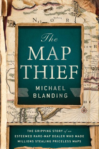
Review: The Map Thief
E. Forbes Smiley III was a well-known and well-connected map dealer, an expert who helped build the Slaughter and Leventhal map collections. Then in 2005 he was caught—on videotape—stealing maps from Yale University’s Beinecke Library. Libraries he had frequented scrambled to check their own holdings and found additional maps missing. Smiley, who cooperated with the authorities, would eventually be sentenced to 3½ years for stealing nearly 100 maps from the British, Boston Public, New York Public, Harvard and Yale libraries, among others. The libraries believed he stole many more.
 With The Map Thief, Michael Blanding presents a book-length exploration of the Forbes Smiley affair, which stunned map collectors and map libraries alike in 2005. Its publication, coming nine years after Smiley’s arrest and four years after his release from prison, is something of an anticlimax, especially for those of us who followed the case so closely as it unfolded (I blogged about it more than 60 times, myself).
Map thieves fascinate us, even if they themselves are not that fascinating (see, for example, the essential blandness of Gilbert Bland, the subject of a previous book about map thefts, Miles Harvey’s Island of Lost Maps), because of what they steal. As stolen goods, antique maps are a curiosity: like art, but more stealable, because there are few copies, not just one.
A Book About the Forbes Smiley Affair
 In 2005 and 2006 my map blog, The Map Room, was full of posts about one E. Forbes Smiley III, who had been caught stealing rare maps from the Beinecke Library at Yale University. As is often the case with map thieves, Smiley was found to be responsible for many other map thefts from other libraries, and suspected in other thefts. Smiley was sentenced to 30 months in prison. (I posted a lot about the Smiley case: see The Map Room’s Map Thefts category archives.)
I knew there would have to be a book on the Smiley case at some point, and one is coming out next month: The Map Thief, whose author, Michael Blanding, has managed to interview Smiley himself, and promises new information about the case. I’m really looking forward to seeing how well Blanding has managed to tell this particular tale, which consumed so much of my attention seven or eight years ago.