trains.fyi maps the real-time locations of North American passenger trains: Amtrak and Via Rail, plus a few commuter lines, based on their GPS tracking data. [Maps Mania]
Tag: trains
European Night Train Network Map

Night train advocacy group Back on Track has a map showing the current network of European night trains offered by various train operators. It’s colour coded by operator, but individual lines are a bit hard to follow, and using various dashed lines for both less-than-daily service and forthcoming service is a bit confusing. Then again, given the sharp uptick of night train services being offered, it’s almost unavoidable that any map of this sort will be a bit of a jumble: compare with Jug Cerović’s version (previously) to see what I mean.
Chronotrains 1911
Benjamin Tran Dinh’s interactive isochrone map of Europe showing how far you can go by train in five hours (previously) has a new variant that does the same thing for 1911 France. Getting closer in time and place to those original isochrone maps. [Maps Mania]
How Far Can You Go in Five Hours? Or on a Single Train?

Benjamin Tran Dinh (previously) has built an interactive isochrone map of Europe that shows you how far you can go by train from a given station in five hours (assuming a connection time of 20 minutes, which is an approximation: generous if same-station, less so if you have to cross the city). The map updates as you move the pointer across it, which is a lot of fun.
The isochrones are generated from data from the direct.bahn.guru site, a site that is worth looking at in and of itself: it shows all the direct connections from a given station, i.e., everywhere you can get to on a single train. That site, in turn, gets its data from the Deutsche Bahn via a legacy API that is necessarily incomplete and only covers destinations reachable from Germany. But there are no complete datasets of European transport routes, so this’ll do. [Maps Mania]
French Rail Services as Network Diagram

Metropolitan France—mainland France without Corsica and its overseas territories—is often referred to colloquially as l’Hexagone. Jug Cerovic, whose work we are familiar with here, has taken that metaphor and run with it with this network diagram of France’s main passenger train lines: the grid is hexagonal, and it works. Lines are colour-coded: TGV lines are blue if they start in Paris and red if they route around it or connect regions directly (a relatively new development; intercity lines are blue-grey, regional lines are orange, and night trains are grey. International routes are also included. It’s actually quite easy to see what cities and towns get what kind of train service, and what services exist between two points—exactly what a network map should do.
James Niehues Creates an Amtrak Network Map Full of Ski Hills

James Niehues is legendary for his pictorial maps of ski resorts—a collection of them was published last year—so it’s no surprise that when Amtrak approached him to create a route map for their on-train magazine, The National, he remained true to his particular idiom, “taking a few liberties to highlight the country’s major ski regions—the Great Plains are shrunken, while the Rockies loom large. ‘I hope nobody takes it too seriously,’ he cautions.”
Previously: Book of Niehues Ski Resort Art Now Available; Crowdfunding a Book of James Niehues’s Ski Resort Art; A Video Profile of James Niehues, Ski Resort Map Artist; James Niehues Passes the Torch; James Niehues’s Ski Resort Maps; James Niehues Profile.
Official and Unofficial German Rail Network Maps Compared
On the left, Deutsche Bahn’s official network map of all Intercity and Intercity Express routes in Germany (PDF). On the right, a much more ambitious map of said network by Reddit user theflyingindonesian. Cameron Booth much prefers the unofficial map: while the official map is “incredibly average” (a putdown I will have to make a point of remembering), the unofficial map is “a major upgrade” that is “infinitely superior” to the official map. “I particularly like the dead straight trajectory of the lines from Hamburg down to Fulda, and the clear treatment of the potentially difficult and convoluted Rhine-Ruhr area. I also like the way that the routes for trains that pass through major stations get a ghosted-back line to link the routes across the (sometimes very large) station rectangles.” I know which one I’d rather spend a long time staring at.
Night Trains

Sleeper trains are making something of a comeback, with services being restored and expanded after years of cutbacks, at least in Europe. In what may not be a coincidence, Jug Cerović has created Night Trains, a collection of maps of overnight train services around the world, done in his usual, standardized schematic transit network design language. Prints are available.
Japanese Rail Network, 1936
Scans from a colourful Japanese rail network map from 1936. Because it’s 1936, the map includes Taiwan, Korea and Manchuria. [via]
The Railway Atlas of Scotland
 Also from Birlinn, The Railway Atlas of Scotland: Two Hundred Years of History in Maps by David Spaven, which came out last October.
Previously: British Railways, Past and Present.
A Map of U.S. Intercity Bus and Train Routes
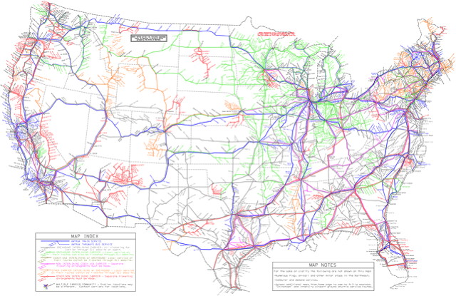
This map from the American Intercity Bus Riders Association (PDF) attempts to map every intercity bus and train route in the United States—i.e., everywhere you can go without a car. It’s a huge, high-resolution, detailed map, and I wouldn’t be surprised if they missed some. [Grist/GIS Lounge]


