Green Mars

irrigated-mars

Kenneth Field’s map of Mars (note updated link) now includes an option to add oceans, with checkboxes to fill the landscape to various elevations.

You can irrigate the planet below the areoid on this map using the water layers. You’ll notice the water layers aren’t blue. On Earth, water appears blue due to red, orange, yellow and green wavelengths of light being absorbed more strongly than blue and also the reflectence of the blue sky. Since Mars has relatively little atmosphere and it’s farther from the sun it’s likely water will appear differently. We’re imagining wavelengths will be absorbed differently, perhaps returning an alien green?

[Maps Mania] A print version is also available: it’s a one-gigabyte PDF that measures 38″×72″ [Kenneth Field].

Previously: Kenneth Field’s Map of Mars.

Topographic Map of Mars

machacek-mars
Image credit: NASA/JPL/GSFC/ASU/USGS/ESA/DLR/FU Berlin (G. Neukum)/Daniel Macháček.

Daniel Macháček released his topographic map of Mars, based on the latest probe data, in November 2014. It uses the Mercator projection between 65° north and 65° south latitude and stereographic projections for the poles. It can be downloaded in insanely high resolution: 17,400×14,700 (78 MB JPEG, 106 MB PDF). His blog post (in Czech: use the translate button) has all the technical details. I particularly like the colour scheme he used for elevation data: the low-lying areas are coloured like deep oceans, which seems appropriate. [Maps on the Web]

New Gravity Map of Mars

mars-gravity-hemispheres
MIT/UMBC-CRESST/GSFC

A new gravity map of Mars, based on data from three orbiting spacecraft, has been released. “Slight differences in Mars’ gravity changed the trajectory of the NASA spacecraft orbiting the planet, which altered the signal being sent from the spacecraft to the Deep Space Network. These small fluctuations in the orbital data were used to build a map of the Martian gravity field.”

Mars Gravity Map
NASA/GSFC/Scientific Visualization Studio

The data enables the crustal thickness of Mars to be determined to a resolution of approximately 120 kilometres. Here’s a short video explaining the significance:

‘Here There Be Robots’: Eleanor Lutz’s Map of Mars

medieval-mars

Eleanor Lutz’s map of Mars isn’t exactly medieval in style (that’s not the right word for it), but it applies an ostensibly old aesthetic to a very modern map subject. “I thought it would be fun to use their historical design style to illustrate our current adventures into unexplored territory. […] Since the base map is hand-drawn I also added an overlay of actual NASA topographic imagery. This way even if some of my lines are a little off, you can still see what the actual ground looks like underneath.” Whatever you call it, it looks amazing. [via]

Space Maps: Ceres, Mars, Exoplanets

Mars: Ares Vallis

Geologic Map of Mars

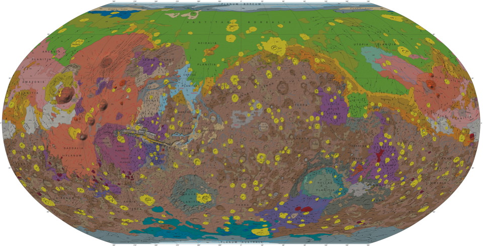
Geologic Map of Mars

As I said during the Q&A part of my fantasy maps presentation at Readercon (see previous entry), maps of other worlds in the solar system are usually images from space probes that have been set to a map projection. The key word is usually. On Monday the U.S. Geological Survey released a geologic map of Mars that “brings together observations and scientific findings from four orbiting spacecraft that have been acquiring data for more than 16 years.” Via io9 and Wired.

More Map Books

Book cover: Mr. Selden's Map of ChinaBook cover: Golden Age of Maritime MapsBook cover: Maps of ParadiseBook cover: International Atlas of Mars Exploration

Here are some map books that I recently found out about: