‘With Savage Pictures Fill Their Gaps’: Chet Van Duzer on Horror Vacui

Chet Van Duzer’s presentation about the lack of empty spaces on old maps—horror vacui—at the November 2017 meeting of the New York Map Society has now been uploaded to YouTube.

As I’ve said before, the subject of empty spaces on maps is of considerable interest to my own research on fantasy maps: fantasy maps tend to be full of empty spaces not germane to the story, whereas real-world maps were covered in cartouches, sea monsters, and ribbons of text. As a result I’m very interested in what Van Duzer has to say about the subject, and have been looking for something exactly like this recorded talk for some time.

I wasn’t disappointed. Van Duzer lays out, with some particularly over the top examples, how empty spaces on maps were consumed (his term) by text, ships, sea monsters and other embellishments that were designed for that very purpose. Some of those embellishments were absolutely enormous, others curiously redundant: a single map does not need four identical scales or a dozen or more compass roses, for example. “Everything we’re seeing here was a choice on the part of the cartographer,” he says at one point; “all this information could be disposed differently.”

Previously: Horror Vacui: The Fear of Blank Spaces.

Book Roundup for January 2018

Augustine Herrman’s Chesapeake

Augustine Hermann, Henry Faithorne, and Thomas Withinbrook. Virginia and Maryland as it is planted and inhabited this present year 1670, 1673. Map on four sheets, 80 × 95 cm. Library of Congress.

A Biography of a Map in Motion: Augustine Herrman’s Chesapeake by Christian J. Koot, out last month from NYU Press, is an exploration of an iconic map—Virginia and Maryland as it is planted and inhabited this present year 1670 (see above)—and the mapmaker behind it, Augustine Herrman. “[T]he map pictures the Mid-Atlantic in breathtaking detail, capturing its waterways, coastlines, and communities. Herrman spent three decades travelling between Dutch New Amsterdam and the English Chesapeake before eventually settling in Maryland and making this map. Although the map has been reproduced widely, the history of how it became one of the most famous images of the Chesapeake has never been told.”

Monsters on the Map

Surekha Davies’s Renaissance Ethnography and the Invention of the Human: New Worlds, Maps and Monsters (Cambridge University Press) came out in June 2016 (see previous entry). In this podcast episode, Davies speaks with host Michael Robinson about the nature of monsters on old maps, and what they meant to contemporary map readers. Runs 28 minutes and is fascinating listening.

New Books in January 2018

Out this month:

  1. Jeremy Black’s Geographies of an Imperial Power: The British World, 1688-1815 (Indiana University Press), an exploration of “the interconnected roles of power and geography in the creation of a global empire.”
  2. Caren Kaplan’s Aerial Aftermaths: Wartime from Above (Duke University Press), a book about the military uses of aerial imagery that explores “how aerial views operate as a form of world-making tied to the times and places of war.”
  3. The Clyde: Mapping the River by John Moore (Birlinn), a book of maps of “arguably the most evocative of Scottish rivers,” came out in the U.K. last October but is available in North America as of this month.

Map Books of 2018

Finally, the Map Books of 2018 page is now live. This is the page I list all the books scheduled to come out this year. It’s constantly in flux as publication dates change and new books are brought to my attention. If there’s a book coming out in 2018 that should be on this page, let me know.

Horror Vacui: The Fear of Blank Spaces

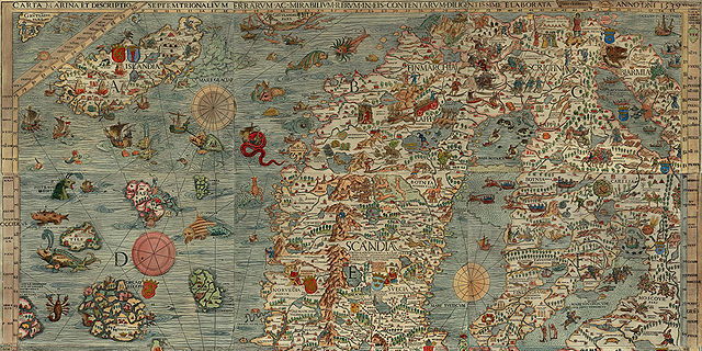
Olaus Magnus, Carta Marina, 1539. Detail. James Ford Bell Library.

In an article I published in 2013, I argued that one key difference between fantasy maps and the real-world medieval and early modern maps they purport to imitate is blank spaces: fantasy maps are full of blank spaces (that which is not in the story is not on the map), whereas real-world maps were covered in cartouches, sea monsters, inset illustrations and other embellishments. One of my sources for that article was a book by Chet Van Duzer: Sea Monsters on Medieval and Renaissance Maps (reviewed here).

Recently Van Duzer has been giving talks on the very subject of the lack of empty spaces on old maps. Which, as you can imagine, is very relevant to my interests. In October he spoke on the subject at the Barry Lawrence Ruderman Conference on Cartography, and earlier this month he gave a similar talk at the New York Map Society. Here’s the abstract from the Ruderman Conference:

Historians of cartography occasionally refer to cartographers’ horror vacui, that is, their fear or hesitancy to leave spaces blank on maps that might be filled with decorations. Some scholars have denied that this impulse was a factor in the design of maps, but the question has never been examined carefully. In this talk I will undertake such an examination, showing that horror vacui was indeed an important factor in the design of maps, at least for some cartographers, from the sixteenth to the early eighteenth century. Some of the factors that motivated cartographers’ concern about empty spaces will also be examined, as will maps by cartographers who evidently did not experience this fear. In the eighteenth and nineteenth centuries maps began to be thought of as more purely scientific instruments, cartographic decoration declined generally, and cartographers managed to restrain their concern about spaces lacking decoration in the interest of presenting their work as modern and professional.​

But since I couldn’t make it to those events, all I had was that tantalizing abstract. (Publish something!) Fortunately, we now have a little more: Greg Miller has written a piece about Van Duzer’s research over on the National Geographic All Over the Map blog.

Olaus Magnus’s Sea Monsters

carta-marina-b
Olaus Magnus, Carta Marina, 1539. Detail. James Ford Bell Library.

Speaking of map monsters, here’s a piece in the Public Domain Review from 2014 that I only encountered this month. It’s a look at the sea serpents found in Olaus Magnus’s 1539 Carta Marina: “The northern seas of the marine and terrestrial map teem with fantastic sea monsters either drawn or approved by Olaus,” writes the author—none other than Joseph Nigg, who literally wrote the book on the Carta Marina’s sea monsters. [WMS]

Previously: Sea Monsters and the Carta Marina.

A New Academic Book on Renaissance Map Monsters

renaissance-ethnographyA new scholarly book about the use of monsters on early modern maps has been brought to my attention. Surekha Davies’s Renaissance Ethnography and the Invention of the Human: New Worlds, Maps and Monsters (Cambridge University Press, June) explores the use of both monsters and indigenous peoples on Renaissance maps. “Giants, cannibals and other monsters were a regular feature of Renaissance illustrated maps, inhabiting the Americas alongside other indigenous peoples. In a new approach to views of distant peoples, Surekha Davies analyzes this archive alongside prints, costume books and geographical writing.” Buy at Amazon. [sourdoughchef]

Previously: Sea Monsters on Medieval and Renaissance Maps.

Sea Monster Shower Curtain

sea-monster-curtain

Retired graphic designer Don Moyer is producing a sea monster shower curtain, inspired by the iconic beasties found on early modern European maps and based on a sea monster print he created last year. It’s a Kickstarter project, but since it’s already been funded, it’s definitely happening. So if your world map shower curtain is beginning to fray, here’s an alternative. [Mental Floss]

The Boston Globe on #MapMonsterMonday

#MapMonsterMonday makes the Boston Globe, in a piece looking at how the Boston Public Library’s Leventhal Map Center curates their weekly posts of map monsters on Twitter and Instagram. (An example below.) Though, to be fair, there are several map library Twitter accounts participating in #MapMonsterMonday. [via]

Bailey Henderson’s Sea Monster Sculptures

Sea monsters are a familiar feature of early modern European maps. Toronto-based sculptor Bailey Henderson has rendered them in real life, casting them in bronze and then painting them. It’s incredible work that really does evoke the original. More details at Hi-Fructose magazine. [via]

For more sea monsters on maps, see my review of Chet Van Duzer’s Sea Monsters on Medieval and Renaissance Maps. You should also be aware that #MapMonsterMonday is a thing on Twitter.

Sea Monsters and the Carta Marina

Carta Marina (top)

Book cover: Sea Monsters (Nigg)It looks like 2013 is the Year of Sea Monsters on Maps. Earlier this year we saw Chet Van Duzer’s Sea Monsters on Medieval and Renaissance Maps (my review); now comes a new study that focuses on a single sixteenth-century map and its many illustrations of seagoing critters: the Carta Marina (1539) by Swedish ecclesiastic Olaus Magnus. Joseph Nigg’s Sea Monsters: The Lore and Legacy of Olaus Magnus’s Marine Map was published last month in the United Kingdom by Ivy Press; in the United States and Canada it’s available from the University of Chicago Press under the title Sea Monsters: A Voyage around the World’s Most Beguiling Map. From the University of Chicago Press page:

Nearly two meters wide in total, the map’s nine wood-block panels comprise the largest and first realistic portrayal of Northern Europe. But in addition to these important geographic elements, Magnus’s map goes beyond cartography to scenes both domestic and mystic. Close to shore, Magnus shows humans interacting with common sea life—boats struggling to stay afloat, merchants trading, children swimming, and fisherman pulling lines. But from the offshore deeps rise some of the most magical and terrifying sea creatures imaginable at the time or thereafter—like sea swine, whales as large as islands, and the Kraken. In this book, Nigg provides a thorough tour of the map’s cartographic details, as well as a colorful look at its unusual pictorial and imaginative elements. He draws on Magnus’s own text to further describe and illuminate the inventive scenes and to flesh out the stories of the monsters.

Buy at Amazon

Review: Sea Monsters on Medieval and Renaissance Maps

Chet Van Duzer’s Sea Monsters on Medieval and Renaissance Maps does what it says on the tin: you really will find out more than you ever wanted to about the sea monsters that appeared on medieval and renaissance maps. (Van Duzer defines them as anything that a contemporary reader would consider exotic, whether it was real or imaginary, so walruses appear along with krakens.) It’s a dizzying catalogue of them, all kinds of them, from medieval mappaemundi (actually, there’s a Roman map in there too) all the way to Ortelius and the late sixteenth century. By the seventeenth century sea monsters were giving way to sailing vessels, and to a loss of ornamentation and illustration in general.

But: sea monsters. What was up with them? For the most part this book gets lost in the weeds, focusing in detail on monster after monster, but Van Duzer does sketch out an argument in the introduction:

First, they may serve as graphic records of literature about sea monsters, indications of possible dangers to sailors — and datapoints in the geography of the marvellous. Second, they may function as decorative elements which enliven the image of the world, suggesting in a general way that the sea can be dangerous, but more emphatically indicating and drawing attention to the vitality of the oceans and the variety of creatures in the world, and to the cartographer’s artistic talents. Of course these two roles are compatible, and sea monsters can play both at the same time. (p. 11)

Van Duzer goes beyond the map in his discussion of sea monsters. For one thing, he points out the non-cartographic sources of sea monsters, such as works of natural history, and compares them to the monsters on the map. He also looks at the economics of sea monsters, which were embellishments that cost extra and may have required a specialist artist: “if the client commissioning the chart did not pay for sea monsters, he or she did not receive them” (p. 10).

For my part, it seems to me that sea monsters in renaissance maps are also holdovers of medieval iconography, sort of a cartographic appendix. Being a big-picture sort, I glazed over a bit at all the detail, but this sort of detail is exactly the sort of thing that illuminates the subject. Between this book and The Art of the Map (reviewed here), I’ve learned quite a bit about the margins and empty spaces of old maps lately.

Previously: Here Be Sea Monsters.

Amazon

Review: The Art of the Map

In The Art of the Map: An Illustrated History of Map Elements and Embellishments, retired history professor Dennis Reinhartz explores the design elements at the margins of western maps from the sixteenth to the nineteenth centuries. It is both a lavishly illustrated book and a close interrogation of the design elements used by western cartographers during the period in question.

From compass roses to cartouches, to sea monsters in the oceans and people and animals in the margins, these elements were used to fill up the otherwise empty corners of a map (of which there were many in this period), set the tone for the map, or otherwise provide information. Most of these elements are gone today (most: National Geographic still makes use of insets and commentaries). Even most fantasy maps, which ape in many ways the maps of this period, may have little more than a cartouche and a compass rose, and are spare in comparison to their historical kin.

Reinhartz organizes his book by elements: ships, sea monsters, plants, animals and people all get their own chapter. With what seems to be a rather small sample of maps, he often returns to the same, familiar maps to discuss a different element. But because The Art of the Map spans more than 300 years, we are not looking at a specific style or usage: the differences between a 16th-century portolan chart and a 19th-century bird’s-eye map of a city are quite substantial.

This book does not make a specific, scholarly argument about these map elements; it’s an appreciation of them, illuminating their essential character by repetitive example. But its intense examination of antique maps’ marginal elements may well open your eyes to, and appreciate, parts of the map that, as present-day readers with present-day map-reading habits, you may well have glossed over.

Amazon

Here Be Sea Monsters

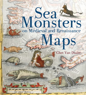
Book cover: Sea Montsers on Medieval and Renaissance Maps Just found out about Chet Van Duzer’s Sea Monsters on Medieval and Renaissance Maps, a new book out this month from British Library Publishing, which explores the monsters drawn on maps from the 10th to the 16th century. From the publisher:

The sea monsters on medieval and Renaissance maps, whether swimming vigorously, gambolling amid the waves, attacking ships, or simply displaying themselves for our appreciation, are one of the most visually engaging elements on these maps, and yet they have never been carefully studied. The subject is important not only in the history of cartography, art, and zoological illustration, but also in the history of the geography of the ‘marvellous’ and of western conceptions of the ocean. Moreover, the sea monsters depicted on maps can supply important insights into the sources, influences, and methods of the cartographers who drew or painted them.

I may have to get this.