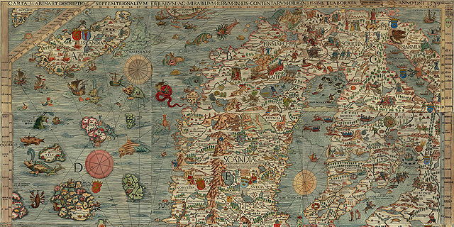
 It looks like 2013 is the Year of Sea Monsters on Maps. Earlier this year we saw Chet Van Duzer’s Sea Monsters on Medieval and Renaissance Maps (my review); now comes a new study that focuses on a single sixteenth-century map and its many illustrations of seagoing critters: the Carta Marina (1539) by Swedish ecclesiastic Olaus Magnus. Joseph Nigg’s Sea Monsters: The Lore and Legacy of Olaus Magnus’s Marine Map was published last month in the United Kingdom by Ivy Press; in the United States and Canada it’s available from the University of Chicago Press under the title Sea Monsters: A Voyage around the World’s Most Beguiling Map. From the University of Chicago Press page:
Nearly two meters wide in total, the map’s nine wood-block panels comprise the largest and first realistic portrayal of Northern Europe. But in addition to these important geographic elements, Magnus’s map goes beyond cartography to scenes both domestic and mystic. Close to shore, Magnus shows humans interacting with common sea life—boats struggling to stay afloat, merchants trading, children swimming, and fisherman pulling lines. But from the offshore deeps rise some of the most magical and terrifying sea creatures imaginable at the time or thereafter—like sea swine, whales as large as islands, and the Kraken. In this book, Nigg provides a thorough tour of the map’s cartographic details, as well as a colorful look at its unusual pictorial and imaginative elements. He draws on Magnus’s own text to further describe and illuminate the inventive scenes and to flesh out the stories of the monsters.
Buy at Amazon


