Error Reporting in Apple Maps

A major feature of Apple’s forthcoming Maps application for OS X 10.9 Mavericks is enhanced error reporting. AppleInsider has the details. This was inevitable, not just because of the uneven quality of Apple’s maps and the reputational firebombing they’ve gotten since their launch last year, but because all online maps suck and need error reporting. Of course, reports are one thing; how quickly and effectively they’re acted on—that’s what’s important.

Previously: Apple Maps on the Mac.

Alberta Flood Maps

This is a list of maps related to the flooding in southern Alberta (Calgary, Canmore, Bragg Creek, High River, Okotoks, etc.). This list will be added to as needed. Feel free to contribute additional links in the comments.

Update, 10:15 PM:

Update, June 22 at 8:25 AM:

Herbal Earth

Herbal Earth
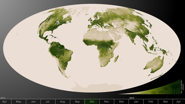
Today NASA released a set of vegetation maps based on data from the Suomi NPP satellite. Flickr photoset, YouTube video. The maps depict a year’s worth of changes in vegetation. “High values of Normalized Difference Vegetation Index, or NDVI, represent dense green functioning vegetation and low NDVI values represent sparse green vegetation or vegetation under stress from limiting conditions, such as drought.” Image credit: NASA/NOAA.

Review: Sea Monsters on Medieval and Renaissance Maps

Chet Van Duzer’s Sea Monsters on Medieval and Renaissance Maps does what it says on the tin: you really will find out more than you ever wanted to about the sea monsters that appeared on medieval and renaissance maps. (Van Duzer defines them as anything that a contemporary reader would consider exotic, whether it was real or imaginary, so walruses appear along with krakens.) It’s a dizzying catalogue of them, all kinds of them, from medieval mappaemundi (actually, there’s a Roman map in there too) all the way to Ortelius and the late sixteenth century. By the seventeenth century sea monsters were giving way to sailing vessels, and to a loss of ornamentation and illustration in general.

But: sea monsters. What was up with them? For the most part this book gets lost in the weeds, focusing in detail on monster after monster, but Van Duzer does sketch out an argument in the introduction:

First, they may serve as graphic records of literature about sea monsters, indications of possible dangers to sailors — and datapoints in the geography of the marvellous. Second, they may function as decorative elements which enliven the image of the world, suggesting in a general way that the sea can be dangerous, but more emphatically indicating and drawing attention to the vitality of the oceans and the variety of creatures in the world, and to the cartographer’s artistic talents. Of course these two roles are compatible, and sea monsters can play both at the same time. (p. 11)

Van Duzer goes beyond the map in his discussion of sea monsters. For one thing, he points out the non-cartographic sources of sea monsters, such as works of natural history, and compares them to the monsters on the map. He also looks at the economics of sea monsters, which were embellishments that cost extra and may have required a specialist artist: “if the client commissioning the chart did not pay for sea monsters, he or she did not receive them” (p. 10).

For my part, it seems to me that sea monsters in renaissance maps are also holdovers of medieval iconography, sort of a cartographic appendix. Being a big-picture sort, I glazed over a bit at all the detail, but this sort of detail is exactly the sort of thing that illuminates the subject. Between this book and The Art of the Map (reviewed here), I’ve learned quite a bit about the margins and empty spaces of old maps lately.

Previously: Here Be Sea Monsters.

Amazon

Apple Maps on the Mac

A Mac version of Apple’s maps was among the new features announced for Mac OS X 10.9 Mavericks at Apple’s Worldwide Developers Conference (WWDC) on Monday. Coverage: 9to5Mac, The Verge. I’m surprised to see that they’re doing it as a standalone application rather than on the Web, which is what I’d expected. One trick of the app is that you can send turn-by-turn directions to your iOS device. There’s an API, so developers will also be able to integrate the maps into their own apps. If they want. Cue old and tired jokes about Apple maps’ quality in three, two …

Review: Here Be Dragons

Stefan Ekman’s Here Be Dragons (Wesleyan University Press, February 2013) is a book-length examination of the use of maps and settings in fantasy literature. Maps and settings. Which is to say that maps are not the sole focus of this work: mark that. There are four main chapters, only one of which deals with maps; the remaining three deal with the issue of borders and territories, the relationship between nature and culture in fantasy cities, and the relationship between ruler and realm. Taken as a whole, this book discusses the role of place in fantasy.

But I won’t be discussing that whole here: I am no literary scholar, and can’t say much of value about the chapters that do not discuss maps—nothing that would rise above the level of a last-minute undergraduate paper, anyway. But maps are something I can say something about, especially fantasy maps, since I myself have been paying attention to them over the past decade, first during my time blogging at The Map Room (see the [old] Imaginary Places category) and since then more sporadically, but with more focus, for my fantasy maps project.

Continue reading “Review: Here Be Dragons”

The Sixteenth-Century Origins of Fantasy Maps

One of the things I’m interested in for my fantasy maps project is the origin of fantasy map design: where does that tell-tale fantasy map look come from?

Look at enough fantasy maps, and it’s hard not to notice certain commonalities in design. As Stefan Ekman demonstrates in Here Be Dragons (yes, I have a review coming—soon!), the maps that accompany fantasy novels tend to be characterized by a number of typical features. “Like much high fantasy,” he writes, “the secondary-world maps follow a pseudomedieval aesthetic according to which dashes of pre-Enlightenment mapping conventions are rather routinely added to a mostly modern creation.”1 Fantasy maps look nothing like medieval maps, and can in many ways be seen as the hybrid descendent of 19th-century amateur mapmaking and early-20th-century children’s book illustrations.

Continue reading “The Sixteenth-Century Origins of Fantasy Maps”