Review: The Cartographers

Book cover: The CartographersI bet you’ve been wondering what I thought about Peng Shepherd’s novel The Cartographers (William Morrow/Orion, March 2022). After all, it’s a literary fantasy about maps: is it even possible for a book to be more relevant to my interests? Well, wonder no longer, because I’ve reviewed it for Strange Horizons.

This piece is a little bit different from the usual review, in that it examines The Cartographers in the context of mysteries and fantasy that deploy similar map tropes, as well as the idées fixes our culture has about maps. As I write in the review, there’s an awful lot for me to unpack:

I have been writing about maps for nearly two decades, and in that time I have encountered many works of fiction that incorporate maps and map tropes into their storytelling, whether as paratexts or as plot elements, and I have never encountered a story, at any length, as thoroughly encompassed by maps as The Cartographers. It’s not just that almost every character in the book works with maps in some fashion, whether as a cartographer, artist, librarian, map dealer, or technician. Nor are maps just a plot point—they are the point. The Cartographers is a Stations of the Map: its pilgrimage follows a path that touches on so many aspects of maps and mapmaking, from academic cartography to fire insurance maps. It spends time on the purpose and meaning of maps: it aspires to an almost Socratic dialogue. It deploys familiar fantasy genre tropes about maps. But it’s structured as a mystery novel, and opens with a murder.

Amazon (Canada, UK) | Apple Books (UK) | Bookshop

Maps and Literature Updates: Two Exhibitions and an Article

The Osher’s fantasy map exhibition, North of Nowhere, West of the Moon: Myth, Fiction, and Fantasy in Maps, is now online—though a number of the exhibition’s maps are unavailable to view, I’m guessing for copyright reasons1 (previously).

Last month, MapLab’s Laura Bliss interviewed the Huntington’s curator of literary collections, Karla Nielsen, about the Huntington’s Mapping Fiction exhibition (previously).

The text of my article “Maps in Science Fiction” is now available online (previously).

New Article from Me: ‘Maps in Science Fiction’

My article “Maps in Science Fiction,” which attempts a taxonomy of the maps that appear in science fiction novels, stories and media, has just been published in the February 2022 issue of The New York Review of Science Fiction.

Maps are a central part of our experience of the fantasy genre: “No Tour of Fantasyland is complete without one,” wrote Diana Wynne Jones in The Tough Guide to Fantasyland; fantasy maps “are only much noticed when they’re absent,” notes The Encyclopedia of Fantasy. It’s easy to forget that maps are also found in science fiction. They don’t turn up as frequently, nor are they expected to, and we don’t talk about them or think about them nearly as often. But they do exist. I’ve been writing about fantasy maps for years, and even I didn’t give science fiction maps the same consideration at least until 2014, when during a presentation about fantasy maps at Readercon, I had to extemporize in response to a question about science fiction maps. My off-the-cuff response led me to look into where and how maps are used in science fiction and from there to write this article on the subject.

This article took a while to come to fruition. I put out a call for examples of science fiction maps and pitched the idea to the NYRSF’s editor back in July 2014—and then life got thoroughly and fundamentally in the way. It was still thoroughly and fundamentally in the way when I finally, finally finished it and sent it off to NYRSF in the summer of 2020. Life was thoroughly and fundamentally in the way at their end, too—thanks, pandemic!—so it’s taken until now to see print at last. I’m glad it has: science fiction maps don’t get a fraction of the attention fantasy maps do, and I think I might have come up with some useful frameworks in this piece.

From the examples explored here, we can discern several functions science fiction maps can perform on behalf of both text and reader. Maps may have a thematic purpose as in the case of maps of Pern or Majipoor in that their style signals a science fantasy environment, the use of fantasy reading protocols, and a text of likely interest to fantasy readers. They may have a storytelling purpose as with the maps from Dune, the Steerswoman series, and the Mars trilogy: the maps separate the known from the unknown, the transformed from the untouched, the colonized from the indigenous. Or they may have a conceptual purpose by giving the reader a big-picture understanding of structures, solar systems, networks, or empires.

I will post the complete text of the article later. In the meantime, if the teasers above have left you unwilling to wait even a little bit, you can buy the NYRSF issue here; it costs just $2.99 in the usual electronic formats.

Update: You can read the article here.

Star Maps: History, Artistry, and Cartography

The March 2020 issue (PDF) of Calafia, the journal of the California Map Society, has as its theme the mapping of space. It also has something from me in it: my review of the third edition of Nick Kanas’s Star Maps: History, Artistry, and Cartography. An excerpt:

It’s important to remember a book’s target audience—its imagined ideal reader. In the case of Star Maps this is Kanas’s younger self, who came to map collecting via his lifelong interest in amateur astronomy. “I was frustrated that there was not a single book on celestial cartography that could inform me about the various aspects of my collecting,” he writes in the preface to the first edition. “What I needed was a book that not only was a primer for the collector but also had sufficient reference detail to allow me to identify and understand my maps. Nothing like this appeared, so I decided to write such a book some day” (p. xxi). In other words, for a compendium this is a surprisingly personal book, one that reflects his own journey into the subject and, presumably, his interests as a collector.

I’ll post the full review on The Map Room once I’ve checked my draft against the published copy. In the meantime, check out the issue of Calafia (PDF) in which it appears. (Update, 24 Jun 2020: Here it is.)


Star Maps: History, Artistry, and Cartography
3rd edition
by Nick Kanas
Springer Praxis, Sept 2019
Amazon (Canada, UK) | Apple Books | Bookshop

Celebrating Christopher Tolkien’s Cartographic Legacy

It turns out that I wasn’t finished talking about the maps drawn by Christopher Tolkien. My latest piece for Tor.com, “Celebrating Christopher Tolkien’s Cartographic Legacy,” went live at Tor.com this morning. It looks at the collaborative process between J. R. R. Tolkien and his son Christopher as father and son tried to make the narrative agree with the map, and vice versa; takes a deep dive into Christopher’s mapmaking technique; and tries to assess the impact of his maps on fantasy mapmaking.

Previously: Christopher Tolkien, 1924-2020.

New at Tor.com: ‘Where Do Fantasy Maps Come From?’

New from me at Tor.com this morning, the latest instalment in my series on the history and design of fantasy maps. “Where Do Fantasy Maps Come From?” looks at the influences on and origins of the fantasy map style—the existing traditions, stretching back as far back as the sixteenth century, that the fantasy map drew upon when it came into being in the early to mid-twentieth century. (Tolkien couldn’t have made it up out of whole cloth, after all.)

This is a speculative piece that draws upon a large and diverse number of sources—everything from Forlani to Berann, from bird’s-eye views of cities to children’s book illustrations—to come up with … well, something interesting, at least. To do proper justice to the subject would require a Ph.D. dissertation. This is a start.

Fantasy Maps Don’t Belong in the Hands of Fantasy Characters

Screenshot from Game of Thrones
HBO

My latest piece for Tor.com went live this morning. It’s called “Fantasy Maps Don’t Belong in the Hands of Fantasy Characters” and it deals with the question of in-world fantasy maps: the maps that characters inside a fantasy novel might use. (Hint: They wouldn’t look like the maps found on the endpapers of a fantasy novel.)

(For some background on how this article came to be, see this post on my personal blog.)

What Does a Fantasy Map Look Like?

New from me on Tor.com this morning: “What Does a Fantasy Map Look Like?” This is the first of several planned pieces that will take a deep dive into the look and feel of fantasy maps: their design and aesthetic, their origins and inspirations, and where they may be going in the future. In this piece, I start by trying to describe a baseline fantasy map style—which, though it’s well recognized and often imitated, has not often been spelled out.

The Writer’s Map

The Writer's MapMy review of The Writer’s Map: An Atlas of Imaginary Lands went live today on Tor.com.

Edited by the historian of exploration Huw Lewis-Jones, The Writer’s Map is a collection of essays and maps that explore the relationship between maps and stories; the essays are written both by the creators of those stories—Cressida Cowell, Lev Grossman, Frances Hardinge, David Mitchell and Philip Pullman make appearances—and by the mapmakers who were inspired by those stories, such as Roland Chambers, Daniel Reeve and others. It also draws an important connection between travel and adventure stories of the past and modern fantasy, and explains why “here be dragons” is as much an attractant as it is a warning. Read my review.

The Writer’s Map is published by Thames and Hudson in the U.K. and by the University of Chicago Press in North America, from which I received a review copy.

Previously: More from (and on) The Writer’s Map; David Mitchell on Starting with a Map; Essays on Literary Maps: Treasure Island, Moominland and the Marauder’s Map.

How to Navigate the Seas of a Flat Fantasy World

How does navigation work on a flat world? Admittedly this is not a question that comes up outside flat earth societies, at least not in the real world, but fantasy worlds aren’t always spherical. Tolkien’s Middle-earth, for example, started off as a flat world, but became round during a cataclysmic event. Before that, the Númenóreans (Aragorn’s ancestors, for those not totally up on their Tolkien lore) were held to be the greatest seafarers in the world: “mariners whose like shall never be again since the world was diminished,” as The Silmarillion puts it. The problem is, a flat earth has implications for navigation: many known methods simply wouldn’t work.

“Mithlond” by Jordy Lakiere

In a piece I wrote for Tor.com,The Dúnedain and the Deep Blue Sea: On Númenórean Navigation,” I try to puzzle out how they could have navigated the oceans of a flat world. I come up with a solution or two, within the limitations of my math abilities. (I’m sure readers who have more math than I do will be able to come up with something better.) It assumes a certain familiarity with Tolkien’s works, and it draws rather heavily on John Edward Huth’s Lost Art of Finding Our Way, which I reviewed here, not at all coincidentally, last month.

Readercon 25

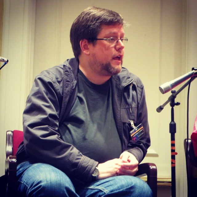
Jonathan Crowe on the Readercon panel I had a very good Readercon. I was a nervous wreck leading up to it, because I had to rewrite the fantasy maps presentation from the ground up. (The first draft was too long and too unfocused. Thanks ever so much to my beta testers who pointed out its flaws the Sunday before the convention.)

Fortunately the presentation on Friday night went off without a hitch—the computer connected properly to the projector, I forgot to stammer—and was very well received: one person called it “probably my favorite event of the con,” which is astonishing when you consider that the con in question is freaking Readercon.

(My presentation also seems to have resulted in Wesleyan University Press selling out its on-hand copies of Stefan Ekman’s Here Be Dragons, which was referenced heavily.)

The Thursday night panel on maps in fiction also seems to have gone over well, based on what I’ve been hearing. It’s not always easy to tell if a panel goes well when you’re leading it: even if it doesn’t turn out the way you expected it to, as was the case here, it may still be a success if the audience enjoys it. Which appears to have been the case. If nothing else, I managed to emit something quotable:

As for the context of that remark, if you weren’t there, I’ll leave that for you to figure out. (I’m working on something along those lines, let me just say.)

For my final panel on Sunday morning, I joined my fellow panellists in a discussion of spoilers. I found myself jumping in and throwing little idea bombs into the discussion, hopefully not too annoyingly or in too derailing a fashion. I saw Scott Edelman recording it on video (the photo above is his) so you may well see the whole thing online at some point.

Meanwhile, I took photos sporadically: here’s the photo album. (Goes without saying that I didn’t bring a camera to my own panels.)

I’d say more, and in more fulsome detail, but I’m off to Detcon 1 in the morning, so this is all you get for now. (This is entirely too little time between conventions.)

My New Article on Fantasy Maps: ‘Here Be Blank Spaces’

NYRSF logo My short essay on fantasy maps, “Here Be Blank Spaces: Vaguely Medieval Fantasy Maps” appears in issue #300 of The New York Review of Science Fiction, out today. I wrote it in response to several books I read rather closely together earlier this year: Reinhart’s Art of the Map, Van Duzer’s Sea Monsters on Medieval and Renaissance Maps, and especially Ekman’s Here Be Dragons (links to my reviews). Taken together, these books highlighted a key difference between fantasy maps and their real-world counterparts from medieval and early modern Europe: fantasy maps are full of blank spaces; real-world maps were not.

Issue #300 of the NYRSF should be available to subscribers now. If you’re not a subscriber, you’re in luck: issue #300 is being made available for free (it’s the NYRSF‘s 25th anniversary, and the publishers are offering it to celebrate and in hopes that you’ll subscribe). Download it from this page. I’ll eventually have it up in the Articles section as well.

Update 8/28: Read the article here.

OpenStreetMap in Ottawa

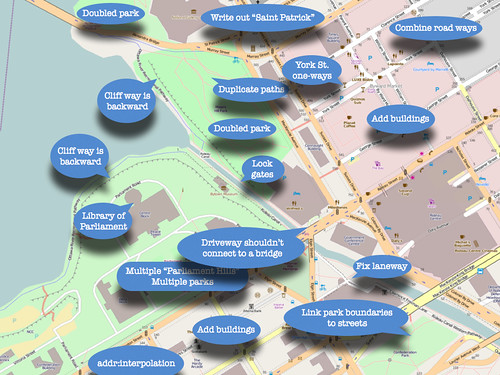
I nearly forgot to mention that last Sunday I gave a presentation on the state of OpenStreetMap in Ottawa to the SummerCamp 2011 Mapping Party. It was a small group — five of us, the majority of whom knew more about the subject than I did — and, due to technical snafus with the meeting location, was held in a Bridgehead coffee shop on Bank Street. All the same, my spiel was well received. I made three points in the presentation: that OpenStreetMap was a lot less complete than some make it out to be; that the OSM map of Ottawa needs a lot of work; and here’s what to do about it.

I suppose that I could make the slideshow available if you’re really interested, but my presentations tend to be talks illustrated by slides, rather than read-the-slides, so without me talking it through it’d be kind of confusing. But here’s the penultimate slide, which shows a screencap of OSM’s map of downtown Ottawa, with things that need fixing helpfully labelled.

Ottawa Mapping Party Presentation

You’ll be happy to know that many of these things have since been fixed.