A Renaissance Globemaker’s Toolbox

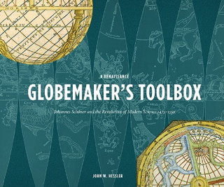
Book cover: A Renaissance Globemaker's Toolbox Briefly noted: A Renaissance
Globemaker’s Toolbox: Johannes Schöner and the Revolution of Modern Science
, John Hessler’s biography of German priest, astronomer and mathematician Johannes Schöner (1477-1547), an early globemaker who, among other things, created the first printed celestial globe gores as well as globe gores for Martin Waldseemüller’s world maps.

The survival of Schöner’s notes and annotations is unique in the history of cartography; not only do they show his thinking about theoretical and practical geography, but they also reveal the art of mapmaking during his lifetime. John Hessler discusses Schöner’s opinions on the canonical geography of Ptolemy, his reaction to the new discoveries of Columbus and Vespucci, and his involvement in the new astronomy of Copernicus. Schöner’s surviving notebooks, manuscripts, and associations with other scientists of the period offer unprecedented insight into the history of these materials, and into the geographical and astronomical concerns that fuelled the birth of modern science development during this critical period in its development.

Buy at Amazon | book website | publisher’s page

Review: The Art of the Map

In The Art of the Map: An Illustrated History of Map Elements and Embellishments, retired history professor Dennis Reinhartz explores the design elements at the margins of western maps from the sixteenth to the nineteenth centuries. It is both a lavishly illustrated book and a close interrogation of the design elements used by western cartographers during the period in question.

From compass roses to cartouches, to sea monsters in the oceans and people and animals in the margins, these elements were used to fill up the otherwise empty corners of a map (of which there were many in this period), set the tone for the map, or otherwise provide information. Most of these elements are gone today (most: National Geographic still makes use of insets and commentaries). Even most fantasy maps, which ape in many ways the maps of this period, may have little more than a cartouche and a compass rose, and are spare in comparison to their historical kin.

Reinhartz organizes his book by elements: ships, sea monsters, plants, animals and people all get their own chapter. With what seems to be a rather small sample of maps, he often returns to the same, familiar maps to discuss a different element. But because The Art of the Map spans more than 300 years, we are not looking at a specific style or usage: the differences between a 16th-century portolan chart and a 19th-century bird’s-eye map of a city are quite substantial.

This book does not make a specific, scholarly argument about these map elements; it’s an appreciation of them, illuminating their essential character by repetitive example. But its intense examination of antique maps’ marginal elements may well open your eyes to, and appreciate, parts of the map that, as present-day readers with present-day map-reading habits, you may well have glossed over.

Amazon

New Google Maps: First Impressions

To be honest, my first impression of the new Google Maps design was how sluggish it seemed. My iMac has a quad-core Ivy Bridge Core i5, a dedicated graphics chipset and a 20-Mbps Internet connection, so I found that a bit disappointing. I didn’t think “resource intensive” would have implications for my current setup. It seemed a little better, though not perfect, using Chrome instead of Safari; Chrome also supports integrated 3D Google Earth mode (Safari is relegated to Lite mode). Performance is going to be something to keep an eye on; I hope they can optimize it.

Eliminating whitespace gives you a nice gigantic map, which is hard to consider bad in any way, but it does feel a bit overwhelming, like there’s too much map to process. Google keeps most of the map, except for major highways, dim for the most part, highlighting relevant content for specific uses—i.e., click on a location and nearest intersecting main streets highlight, ask for directions and exit numbers appear even at high zooms. It’s very, very subtle, something you might not notice. Much of the interface is moved from the sidebar to the map: Street View is accessed by clicking the road, for example—Pegman is nowhere to be seen.

Kenneth Field has some thoughts on the new maps, particularly in terms of whether Google has succeeded in creating personalized cartography. AppleInsider’s glee at discovering the same sort of image distortions that were called out in Apple’s maps last fall is plain for anyone to see.

Have you had a chance to play with it yet?

Here Be Sea Monsters

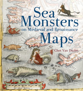
Book cover: Sea Montsers on Medieval and Renaissance Maps Just found out about Chet Van Duzer’s Sea Monsters on Medieval and Renaissance Maps, a new book out this month from British Library Publishing, which explores the monsters drawn on maps from the 10th to the 16th century. From the publisher:

The sea monsters on medieval and Renaissance maps, whether swimming vigorously, gambolling amid the waves, attacking ships, or simply displaying themselves for our appreciation, are one of the most visually engaging elements on these maps, and yet they have never been carefully studied. The subject is important not only in the history of cartography, art, and zoological illustration, but also in the history of the geography of the ‘marvellous’ and of western conceptions of the ocean. Moreover, the sea monsters depicted on maps can supply important insights into the sources, influences, and methods of the cartographers who drew or painted them.

I may have to get this.

A Topographic Map of Titan

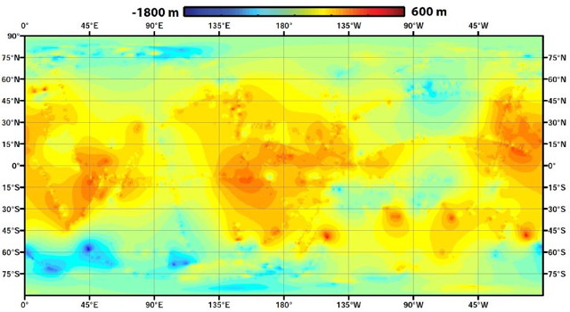
Global topographic map of Titan (NASA/JPL-Caltech/ASI/JHUAPL/Cornell/Weizmann)
NASA/JPL-Caltech/ASI/JHUAPL/Cornell/Weizmann

The Cassini team has released a global topographic map of Saturn’s moon Titan. What makes this map interesting is the fact that, due to its thick atmosphere, Titan can only be mapped by radar during Cassini’s close flybys. As a result, only half of its surface has been imaged, and only 11 percent has topography data. For this map, the remainder was, well, extrapolated:

Lorenz’s team used a mathematical process called splining—effectively using smooth, curved surfaces to “join” the areas between grids of existing data. “You can take a spot where there is no data, look how close it is to the nearest data, and use various approaches of averaging and estimating to calculate your best guess,” he said. “If you pick a point, and all the nearby points are high altitude, you’d need a special reason for thinking that point would be lower. We’re mathematically papering over the gaps in our coverage.”

Topo maps of parts of Titan have been released before, but not for the entire moon. See previous posts on The Map Room: Titan in Stereo; Topography of Titan.

Google Maps Redesigned

Google announced a complete redesign of Google Maps at their I/O developer conference yesterday. The new maps are vector-based, take up the entire browser window and change based on the context—highlighting certain streets, for example, based on a search—and your usage patterns. It’s also apparently quite resource intensive: these are maps designed for fast processors and fast Internet connections. It’s just an invite-only preview at the moment. For coverage see Engadget and The Verge.

OpenStreetMap’s New Map Editor

OpenStreetMap has launched a new map editing interface that runs, for the first time, in HTML5. (Potlatch, the previous web-based map editor, uses Flash, and JOSM runs in Java, which I always thought was ironic for an open project.) The editor, called iD, is live now, and is designed to make editing the map more accessible to beginning mapmakers. I’ve given it a quick try this morning. My summary judgment is that if you have any experience using another editor, you should stick with it. iD is far slower than Potlatch at the moment, and does things sufficiently differently that you might have a hard time finding things. I made a mess trying to edit the existing map. But will it lower the barrier to making new contributions, particularly for casual or non-technical contributors? I hope so.