First Geologic Map of Titan

Geologic map of Titan
NASA/JPL-Caltech/ASU

The first global geologic map of Titan, based on radar and infrared data from the Cassini probe, has been released.

The map legend colors represent the broad types of geologic units found on Titan: plains (broad, relatively flat regions), labyrinth (tectonically disrupted regions often containing fluvial channels), hummocky (hilly, with some mountains), dunes (mostly linear dunes, produced by winds in Titan’s atmosphere), craters (formed by impacts) and lakes (regions now or previously filled with liquid methane or ethane). Titan is the only planetary body in our solar system other than Earth known to have stable liquid on its surface—methane and ethane.

The map is the result of research published today in Nature Astronomy.

Previously: Titan in Infrared; Mapping Titan with VIMS; A Topographic Map of Titan.

National Geographic’s Atlas of Moons

The Atlas of Moons (screenshot)

The Atlas of Moons is National Geographic’s interactive guide to every single moon in the solar system (except for a few moons of dwarf planets and asteroids that we know next to nothing about). The big ones get interactive globes and additional description (as do Mars’s moons Phobos and Deimos, because we have imagery for them). Note that this is an extremely resource-intensive page that will use gigabytes of RAM if you let it.

Digital Museum of Planetary Mapping

Camille Flammarion, “Mappemonde géographique de la planète Mars,” Terres du Ciel, 1884.

The Digital Museum of Planetary Mapping is an online collection of maps of the planets and moons of our solar system. There are more than two thousand maps in the catalogue, some dating as far back as the 17th century, but the bulk of them, understandably, are much more recent; also understandably, Mars and the Moon are the subject of most of the maps (40 and 46 percent, respectively).

The site is more like a blog than a library catalogue: it’s powered by WordPress and the individual listings are blog posts, but that’s perfectly legitimate, albeit less elegant. (But then who am I to judge?)

The project was presented at the European Planetary Science Congress in Berlin last month: for news coverage, see Phys.org and Space.com; the press release is here. [WMS/WMS]

Radiation Map of Europa

U.S. Geological Survey, NASA/JPL-Caltech, JHUAPL, Nature Astronomy.

I knew that Europa, like Jupiter’s other major moons, was absolutely baked by radiation coming from Jupiter (Wikipedia reports it at 5.4 Sv/day, a lethal dose). It did not occur to me that that radiation was not evenly distributed. In preparation for future missions to Europa, a new study, using Galileo and Voyager data, tries to map where the radiation is most intense on the Europan surface, as well as how far that radiation penetrates beneath the surface. If there’s life on Europa, it’s probably where the radiation isn’t. [JPL]

Titan in Infrared

NASA/JPL-Caltech/University of Nantes/University of Arizona

Because of its thick and opaque atmosphere, Titan had to be mapped in radar and infrared during a series of close flybys by the Cassini spacecraft. One artifact of this process: the resolution, lighting and atmospheric conditions were not consistent, so mosaic images and maps of Titan’s surface showed visible seams. That’s been corrected in these infrared images of Titan’s surface, released last week. The false-colour images remap infrared wavelengths to the visible spectrum, using a band-ratio technique that minimizes seams. “With the seams now gone, this new collection of images is by far the best representation of how the globe of Titan might appear to the casual observer if it weren’t for the moon’s hazy atmosphere, and it likely will not be superseded for some time to come.”

Previously: Mapping Titan with VIMS.

Moons and Planets added to Google Maps

Google Maps (screenshot)

The Moon and Mars were relatively early additions to Google Earth; that application may have been migrated to the web, but the planets and moons keep coming. Yesterday Google announced the addition of a dozen other worlds in our solar system; the space layer of Google Maps now includes planets Mercury, Venus and Mars; dwarf planets Ceres and Pluto;1 Jupiter’s moons Io, Europa and Ganymede; and Saturn’s moons Dione, Enceladus, Iapetus, Mimas, Rhea and Titan. Large moons Callisto and Triton aren’t included, and Iapetus is projected onto a sphere rather than appearing as the bizarre space walnut it is.

The Planetary Society’s Emily Lakdawalla noticed a thing, though:

Emily reports that this bug affects several moons of Jupiter and Saturn; Google is apparently already on it and may have fixed it by the time you read this.

3D Printed Planetary Globes

3d-printed-planets

On Shapeways, a site where users can upload and sell 3D-printed items, George Ioannidis is selling globes of the planets and moons of our solar system. There are individual globes, globes that take into account moons’ irregular topography (e.g. Phobos and Diemos, Iapetus), all in different sizes (none of which are very big: 50 to 200 mm), and collections where each planet and moon is to scale (as seen above, this can be somewhat unwieldy, but it’s neat for Jupiter’s Galilean moons, for example). I’m unreasonably enthusiastic about this sort of thing. [via]

Previously: Globes of the Solar System.

Ganymede and Mercury

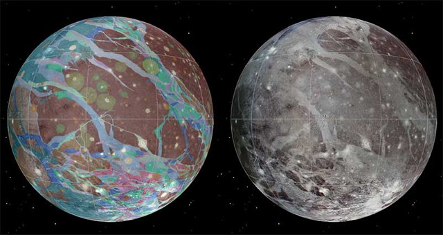
Geologic map of Ganymede

The USGS has published a geologic map of Ganymede, Jupiter’s largest moon and the largest moon in the Solar System, based on imagery from the Voyager 1, Voyager 2 and Galileo probes. Via Centauri Dreams, Sky and Telescope.

Meanwhile, Sky and Telescope has produced a Mercury globe based on MESSENGER imagery. They already produce both visual and topographic globes of the Moon and Mars, as well as a globe of Venus coloured for elevation. (I’m crossing my fingers for globes of the outer moons, myself.)

I’m big on maps and globes of the rest of the Solar System. Recent entries: Maps of Mercury; Atlas of Vesta; A Topographic Map of Titan.

A Topographic Map of Titan

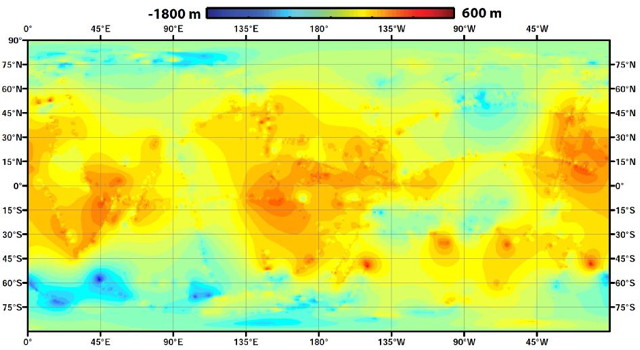
Global topographic map of Titan (NASA/JPL-Caltech/ASI/JHUAPL/Cornell/Weizmann)
NASA/JPL-Caltech/ASI/JHUAPL/Cornell/Weizmann

The Cassini team has released a global topographic map of Saturn’s moon Titan. What makes this map interesting is the fact that, due to its thick atmosphere, Titan can only be mapped by radar during Cassini’s close flybys. As a result, only half of its surface has been imaged, and only 11 percent has topography data. For this map, the remainder was, well, extrapolated:

Lorenz’s team used a mathematical process called splining—effectively using smooth, curved surfaces to “join” the areas between grids of existing data. “You can take a spot where there is no data, look how close it is to the nearest data, and use various approaches of averaging and estimating to calculate your best guess,” he said. “If you pick a point, and all the nearby points are high altitude, you’d need a special reason for thinking that point would be lower. We’re mathematically papering over the gaps in our coverage.”

Topo maps of parts of Titan have been released before, but not for the entire moon. See previous posts on The Map Room: Titan in Stereo; Topography of Titan.

Atlas of the Galilean Satellites

Paul Schenk’s Atlas of the Galilean Satellites (Cambridge University Press, 2010) collects all the imagery gathered by the Voyager and Galileo missions of the four major moons of Jupiter (Callisto, Ganymede, Europa and Io, all discovered by Galileo in 1610) and assembles them into global, quadrangle and area maps. But this heavy, 400-page tome begins with a confession. “This Atlas is not what it should be.” The failure of the high-gain antenna on the Galileo spacecraft meant that far less data could be transmitted back to Earth during its nearly eight-year mission than had been planned. Large tracts of the moons are mapped in low resolution; the fuzzy images yield little detail. But until another mission is sent—the Juno probe now en route to Jupiter will not be studying the moons—this is all there will be for the foreseeable future. For decades, in fact.

The Atlas of the Galilean Satellites therefore represents a treasure trove of all available imagery of these four moons. The further out you go, the less imagery there is: outermost Callisto gets 49 pages of plates, innermost Io, with all its interesting volcanoes, gets 89. Despite the inevitable blurry patches, there are some extraordinarily high-detail images here. One problem, though, is that the global maps are unlabelled; I found it difficult to place features that were labelled on the quadrangle, regional and detail maps in their global context. Also worth noting is that—and I suspect this is the norm for extraterrestrial mapping—these are not maps per se, but spacecraft imagery labelled and put on a map projection.

One issue that has been noted elsewhere—for example, in Emily Lakdawalla’s review last November—is that several copies of this book have been defective, with pages falling out. My own copy is fine, but seems a bit fragile. (UPDATE: Laying it open flat once was enough for several pages to come loose.) The signatures appear to be glued rather than sewn—a textbook example of the badly built British book—which is inexplicable given the size of the book and weight of the glossy paper, to say nothing of its cost. Because, at $165 (£95) list, this book is extremely expensive; ebook versions are just as exorbitant. Cheaper copies can be found elsewhere with a little digging: I got mine via AbeBooks for less than $30, shipping included. Honestly, given the risk of the book falling apart on you, that’s the way to go.

This atlas isn’t really aimed at beginners or people with a casual interest in the solar system. The price reflects that, as does its rather technical nature and organization. Those with a serious jones for the solar system will not be deterred by these or any other reservations.

Previously: Blogs and a Book About Maps of the Solar System’s Moons.

Amazon | iBooks