Moons and Planets added to Google Maps

Google Maps (screenshot)

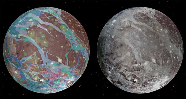
The Moon and Mars were relatively early additions to Google Earth; that application may have been migrated to the web, but the planets and moons keep coming. Yesterday Google announced the addition of a dozen other worlds in our solar system; the space layer of Google Maps now includes planets Mercury, Venus and Mars; dwarf planets Ceres and Pluto;1 Jupiter’s moons Io, Europa and Ganymede; and Saturn’s moons Dione, Enceladus, Iapetus, Mimas, Rhea and Titan. Large moons Callisto and Triton aren’t included, and Iapetus is projected onto a sphere rather than appearing as the bizarre space walnut it is.

The Planetary Society’s Emily Lakdawalla noticed a thing, though:

Emily reports that this bug affects several moons of Jupiter and Saturn; Google is apparently already on it and may have fixed it by the time you read this.

The First Global Topographic Map of Mercury

mercury-topo-robinson-nolabels

The first complete topographic map of Mercury, based on data from the MESSENGER mission, was released last Friday: MESSENGER, USGS. The version above is a Robinson projection without labels (Robinson with labels, global DEM). “Mercury’s surface is colored according the topography of the surface, with regions with higher elevations colored brown, yellow and red, and regions with lower elevations appearing blue and purple.” [GIS and Science, The National Map]

Ganymede and Mercury

Geologic map of Ganymede

The USGS has published a geologic map of Ganymede, Jupiter’s largest moon and the largest moon in the Solar System, based on imagery from the Voyager 1, Voyager 2 and Galileo probes. Via Centauri Dreams, Sky and Telescope.

Meanwhile, Sky and Telescope has produced a Mercury globe based on MESSENGER imagery. They already produce both visual and topographic globes of the Moon and Mars, as well as a globe of Venus coloured for elevation. (I’m crossing my fingers for globes of the outer moons, myself.)

I’m big on maps and globes of the rest of the Solar System. Recent entries: Maps of Mercury; Atlas of Vesta; A Topographic Map of Titan.

Maps of Mercury

H-12 Michaelangelo

The USGS has released quad maps of the planet Mercury as a set of PDF files: “The 1:5 million-scale series of Mercury maps divides Mercury into 15 quadrangles, H-1 through H-15 (five Mercator, eight Lambert Conformal, and two Polar Stereographic quadrangles). The base mosaic was produced with orbital images by the MESSENGER Team and released by NASA’s Planetary Data System on March 8, 2013. This new global mosaic includes 100% coverage of Mercury’s surface.”