Bespoke globemaker Bellerby and Company is putting the finishing touches on a one-of-a-kind globe that will be auctioned to raise funds for the defence and rebuilding of Ukraine. “One of our talented painters, Anastasiya (Nastia), has been in the company close to 5 years. She is hand painting traditional Ukrainian folk art directly on to this unique and special globe.” The globe is inspired by Petrykivka painting. More at their Instagram post.
Category: Art
xkcd: The Goode Homolosine to the Rescue!
Randall Munroe’s map projection humour is increasingly on point, as last Friday’s xkcd demonstrates. (The mouseover text is even better: “There are two rules on this ship: Never gaze back into the projection abyss, and never touch the red button labeled DYMAXION.”)
Previously: xkcd: The Greenland Special; xkcd: All South Americas; Blame the Mercator Projection; xkcd’s Time Zone Map; xkcd’s Liquid Resize Map Projection.
CityLab Continues Its COVID Mapping Project
Bloomberg CityLab is continuing its COVID-19 mapping project: they’ve issued another call for reader-submitted maps. “[T]he new year is a chance to take stock of where we stand now. Once again, Bloomberg CityLab invites you to make a map that reflects on how your world has shifted or been reframed during the pandemic.” Due date is 17 January.
Previously: CityLab Wants Your Hand-Drawn Quarantine Maps; Maps from Isolation; CityLab Wants Your Homemade Map of 2020.
Preorder The Quarantine Atlas: Mapping Life under COVID-19 at Amazon (Canada, UK).
Max Schörm’s Modern Caricature Maps
Max Schörm has resurrected the art of caricature maps (maps where countries are made to look like people, animal or other objects; they were a regular feature of propaganda maps of the late 19th and early 20th centuries). For the past year and a half Max has been posting new maps three times a week to his Instagram account: the maps are of countries, but also continents, provinces, states, districts and cities; some of them are of countries’ historical boundaries (e.g. interwar Romania or Habsburg Hungary—or, going even further back, Pangaea) some of them (e.g. this pinwheel map of Myanmar) are even animated. There’s a lot of whimsy and pop-culture references that don’t always match up with the borders they’re filling out; these aren’t the “serio-comic” satirical maps of the pre-World War I era. Which is to say: they’re entertaining.
Previously: A ‘Serio-Comic Map’ for the Modern Age; Another Caricature Map of Modern Europe.
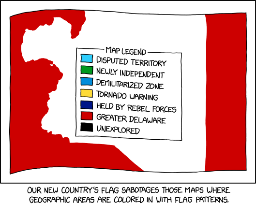
xkcd Sabotages Those Flag Maps
Maps where countries are coloured in with flag patterns: I’ve seen a lot of them around, especially on Reddit, but I haven’t necessarily liked them; xkcd’s comic from last Wednesday goes one step further in that it offers a way to hack them.
A Map of Every Chinese City
Inspired, he says, by Itchy Feet’s maps of Every European City and Every American City, Alfred Twu has come up with a Map of Every Chinese City. (Chinese version here.) Twu is no stranger to these parts: he worked on rail maps for California and the Northeast Corridor some years back.
Previously: Itchy Feet’s Map of Every European City; Itchy Feet’s Map of Every American City.
Niehues Moves On from Ski Resort Maps
Legendary ski resort map artist James Niehues has announced on his blog and on Twitter that he will be “stepping away from creating ski resort trail maps” after more than three decades. He plans to work on other projects, including the American Landscape Project, and will, for the first time, be selling original paintings and sketches of his ski resort trail maps later this month.
Dreading the Map
Sonia E. Barrett’s Dreading the Map is an explicitly anti-colonial work installed in the heart of one aspect of British colonialism: the Map Room of the Royal Geographical Society.
Using carefully curated paper maps of the Caribbean and UK that have been shredded into strips, the artist and several black women co-creators used African-Caribbean hair styling techniques to plait the shredded maps. Culturally, such female spaces of hair styling are filled with discussions around self- and community-care, and this black woman-centred cultural practice juxtaposed the wood-lined walls, globes and portraits of white explorers that typify the building with the music and laughter of black women talking and working together. As a response to the RGS’s stated desire to reflect on their history and their building, this was a filling of the space with black women’s language, perspectives and practices, a reimagining of what the space can and should mean.
Dreading the Map is one of several “artistic provocations” commissioned by CARIUK. It has been installed in the RGS’s Map Room since March. On 24 May the RGS hosted a conversation with Sonia E. Barrett about the work.
Algonquin Bead Artist to Reinterpret Cold War Maps
The Diefenbunker is a Cold War-era fallout shelter on the outskirts of Ottawa that has since been converted into a museum. Its large floor maps, never used or displayed, are serving as grist for an Indigenous artist in residence, CBC Ottawa reports:
As the new artist in residence at Ottawa’s Diefenbunker Museum, Mairi Brascoupé is blending Cold War-era maps and beadwork to explore the idea of “place” during times of change.
Brascoupé, a member of Kitigan Zibi Anishinabeg First Nation, wants to weave her own story by exploring the differences between cultures of Indigenous people and settlers.
She plans to use waterways and traplines in contrast with fallout zones, evacuation plans, and other details of the museum’s maps.
Peter Bolt’s Bespoke 3D Relief Models
Since 2013, Peter Bolt—whose company is called Landfall—has been making bespoke 3D relief models based on from nautical charts, Ordnance Survey maps and aerial photographs (see his portfolio for examples). The models are layered along contour lines—a process that can be seen in several of his videos. Everything is a custom job, made by hand; prices begin around £250 for an A4-sized model and go up from there.
Cross-stitched Earth Science Maps
Kara Prior cross-stitches earth science maps; her work includes a series of state bedrock geology maps (see also Reddit) and a bathymetry map of the Great Lakes (above), among other things. She has an Etsy store.
Atlas Obscura Interviews James Niehues
In an interview with Atlas Obscura’s Max Ufberg, legendary ski resort map artist James Niehues (no stranger to us here at The Map Room: previously) discusses some of the challenges involved in creating his paintings. For example:
What’s the most challenging aspect of the work?
Showing all the trails in the most understandable and navigational way. It may not always be in one view, but I strive for the single view because it leaves no doubt about any trail connections or direction. Many mountains have slopes on more than one face, which requires manipulating the features to show the back side with the front on a flat sheet of paper. This has to be done with care since skiers will be referring to the image to choose their way down; all elements have to be relative to what they are experiencing on the mountain.
[via]
Maps at Year’s End
Kenneth Field has posted his favourite maps from the past year—something he’s been doing since 2013. Quite a diverse set, from the Johns Hopkins coronavirus dashboard to a Lego model of Manhattan: you won’t have seen all of them.
CityLab has posted a selection of reader maps that explore how their lives were affected by 2020. Coronavirus, change and disruption are recurring themes. “We hope these maps offer readers a sense of solace and solidarity, a chance for reflection or provocation, and perhaps even a breath of creative inspiration.” (Previously: CityLab Wants Your Homemade Map of 2020.)
CityLab Wants Your Homemade Map of 2020
Earlier this year CityLab invited readers to submit maps of their life under lockdown. Now they’re soliciting reader maps again, with a slightly expanded focus: 2020 in general. (Which, in general, was a year: how do you represent that cartographically? That’s the idea.)
We’re inviting you, our readers, to create a homemade map of your life, community, workplace or broader surroundings as you experienced them in 2020. Show us how the extraordinary changes of this year have shown up in your life. Or, try to envision how this year will impact 2021. Perhaps you want to map the city you hope to see—changes in architecture, transportation or public space—or how you imagine, hope or fear humanity might be changed due to this collectively lived experience.
Deadline is Monday, 7 December.
Previously: CityLab Wants Your Hand-Drawn Quarantine Maps; Maps from Isolation.
Making 3D Art from Old Geological and Relief Maps
Apparently independently of one another, Sean Conway and Dmitriy Worontzov have been taking old geological and relief maps and applying using digital elevation models to apply 3D effects to them. The end result is a two-dimensional image, or a print, but it’s hard to shake the feeling that these maps now have real depth and texture. Conway, an orthoimagery specialist, works mainly on old U.S. relief maps; the results are available for sale as posters. Read more about him at My Modern Met. Worontzov, a Moscow-based art director, goes for geological maps, mainly from the Soviet era; see his work on Behance and Instagram, and read about him at Abduzeedo. [Alejandro Polanco, WMS]